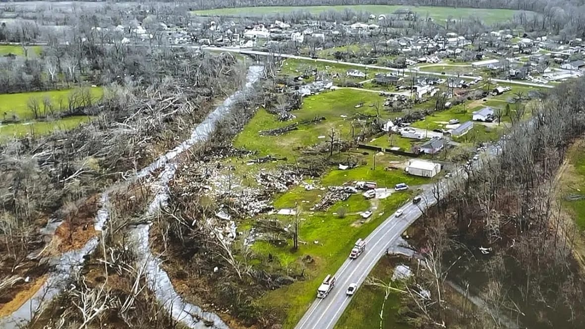
ST. LOUIS (AP) — A large tornado tore through southeastern Missouri on Wednesday, causing widespread destruction and killing multiple people as a broad swath of the Midwest and South braced for further storms that could spawn additional twisters and hail.
The tornado touched down before dawn and moved through a rural area of Bollinger County, about 50 miles (80 kilometers) south of St. Louis, said Sgt. Clark Parrott of the Missouri State Highway Patrol. He said it caused “multiple injuries and multiple deaths,” but he didn’t specify how many or say precisely where they occurred.
“The damage is pretty widespread. It’s just heartbreaking to see it,” Parrott said.

He said said a search and rescue operation involving multiple agencies was underway and that crews had to use chainsaws to cutback trees and brush to reach some homes.
The patrol posted an overhead photo of the damage that showed uprooted trees and homes that had been reduced to rubble.
Justin Gibbs, a National Weather Service meteorologist in Paducah, Kentucky, said the tornado touched down at around 3:30 a.m. and remained on the ground for roughly 15 minutes, traveling an estimated 15-20 miles (24-32 kilometers).
A weather service team was headed to Bollinger County to gather details about the tornado, but Gibbs said it’s clear “it was big. It was a significant tornado.”
He noted that tornadoes are especially dangerous when they touch down late at night or early in the morning, as this one did.
“It’s definitely a nightmare from a warning standpoint,” Gibbs said. “It’s bad anytime, but it’s especially bad at 3:30 in the morning.”
The storms moving through the Midwest and South threaten some areas still reeling from a deadly bout of bad weather last weekend. The Storm Prediction Center said up to 40 million people in an area that includes major cities including Chicago, Indianapolis, Detroit and Memphis, Tennessee, were at risk from the storms later Wednesday. As of late Wednesday morning, the the greatest threat appeared to be to an area stretching from lower Michigan into Tennessee and Kentucky.
Fierce storms that started last Friday and continued through the weekend spawned deadly tornadoes in 11 states as the system plodded through Arkansas and into the South, Midwest and Northeast.
Schools in Little Rock, Arkansas, canceled Wednesday classes because the storms were expected to move through the area during the morning rush, KFVS-TV reported.
At least two tornadoes were confirmed Tuesday in Illinois as storms targeted the state and eastern Iowa and southwest Wisconsin before nightfall.
The National Weather Service issued tornado warnings in Iowa and Illinois on Tuesday evening and said a confirmed twister was spotted southwest of Chicago near Bryant, Illinois. Officials said another tornado touched down Tuesday morning in the western Illinois community of Colona. Local news reports showed wind damage to some businesses there.
Earlier Tuesday, strong thunderstorms swept through the Quad Cities area of Iowa and Illinois, with winds up to 90 mph (145 kph) and baseball-sized hail. No injuries were reported, but trees were downed and some businesses were damaged in Moline, Illinois.
Northern Illinois, from Moline to Chicago, saw 75-80 mph (120-128 kph) winds and hail 2 to 3 inches (5 to 8 centimeters) in diameter Tuesday afternoon, National Weather Service meteorologist Scott Baker said. The agency received reports of semitrucks tipped over by winds in Lee County, about 95 miles (153 km) west of Chicago.
The same conditions that fueled those storms — an area of low pressure combined with strong southerly winds — were setting up the severe weather Tuesday into early Wednesday, said Ryan Bunker, a meteorologist with the National Weather Center in Norman, Oklahoma.
Those conditions, which typically include dry air from the West going up over the Rockies and crashing into warm, moist air from the Gulf of Mexico, are what make the U.S. so prone to tornadoes and other severe storms.
TheGrio is FREE on your TV via Apple TV, Amazon Fire, Roku and Android TV. Also, please download theGrio mobile apps today!

